class: center, middle, inverse, title-slide # Urban Lunch Series - Order Without Design ## City Density Gradients ### Jens von Bergmann & Nathan Lauster ### 2021-07-08 --- <style> .large { font-size: 130%;} .small { font-size: 70%;} .tiny{font-size: 40%;} .width-40 {width: 40%;} .width-30 {width: 30%;} .width-65 {width: 65%;} .width-75 {width: 75%;} .width-20 {width: 20%;} .less-top-margin {margin-top:-120px;} </style> ## Density When we talk about **density** in the context of cities it can refer to several related concepts. * Residential density ("nighttime" population density) * Job density ("daytime" population density) * Building density We will talk about all of these, their spatial distribution, and the relationship between them. --- ## Density Gradients .pull-left[ We now have global population datasets on fine geographies that enable us to study and compare how population clusters within cities in terms of residential densities. ] [<img src="https://doodles.mountainmath.ca/posts/2019-03-17-city-density-patterns_files/figure-html/vancouver_comparison-1.png" height="450px"/>](https://doodles.mountainmath.ca/blog/2019/03/17/city-density-patterns/) --- ## Density over time Bangkok We can also see how residential densities change over time. Here's Bangkok, illustrating how densities might be expected (following Bertaud) to develop in way that decreases exponentially with distance from city centre. [!<img src="https://d33wubrfki0l68.cloudfront.net/15b456744e329360deed0dcda78b1e10ae9349b6/9d78c/posts/2019-03-27-density-timelines_files/figure-html/bangkok-1.png" height="425px"/>](https://doodles.mountainmath.ca/blog/2019/03/27/density-timelines/) --- ## Density over time Vancouver Here's Vancouver, where we also get a glimmer of this pattern. But notice it doesn't fit quite so well. [!<img src="https://doodles.mountainmath.ca/posts/2019-03-27-density-timelines_files/figure-html/vancouver-1.png" height="450px"/>](https://doodles.mountainmath.ca/blog/2019/03/27/density-timelines/) --- ## Job density (daytime population) Though the data is less consistent or fine-grained, we can also take a static look at job density, getting a sense of daytime population density (at least pre-pandemic). <img src="images/job_density.png" height="500px"/> --- ## Buildings (FSR) People generally go where the buildings are. Building density can be measured a couple of different ways. Here we can look at it in terms of building floor splace to lot size, often referred to as Floor Space Ratio (FSR or FAR). [<img src="images/fsr_estimate.png" height="400px">](https://mountainmath.ca/map/assessment?zoom=12&lat=49.2594&lng=-123.1047&layer=16&mapBase=2) --- ## Buildings (Height) Building heights is another way to measure building density. Here is a graph motivated by similar [work by Jim Gleeson for London and Paris](https://twitter.com/geographyjim/status/994949659461341184?s=20). [!<img src="https://doodles.mountainmath.ca/posts/2018-05-11-building-height-profiles_files/figure-html/building_height_profile_dual-1.png" height="450px"/>](https://doodles.mountainmath.ca/blog/2018/05/11/building-height-profiles/) --- ### How did it get this way? The railroad explains why density ultimately concentrated in Vancouver. But what about those density gradients? <img src="images/port_moody.jpg" height="450px"/> --- ### Order by Design Serious city planning began in 1920s & by decade's end American planner Harland Bartholomew famously laid out designs meant to carry Vancouver through to 1960. By then [Vancouver was projected to merge with Burnaby & New Westminster, hit 1 million residents, and require new planning for further expansion](https://doodles.mountainmath.ca/blog/2021/02/03/bartholomew-s-dot-destiny/). (We're still not merged, and the peninsula only hit 1 million residents within the last 5 years) .pull-left[ #### Bartholomew projected 1 million residents by 1960 [<img src="https://doodles.mountainmath.ca/images/bartholomew_population_original.png"/>](https://doodles.mountainmath.ca/blog/2021/02/03/bartholomew-s-dot-destiny/) ] .pull-right[ #### 2016 actual population reaching (almost) 1 million residents [<img src="https://doodles.mountainmath.ca/posts/2021-02-03-bartholomew-s-dot-destiny_files/figure-html/vancouver-dot-2016-1.png"/>](https://doodles.mountainmath.ca/blog/2021/02/03/bartholomew-s-dot-destiny/) ] --- ### Modern Zoning The City of Vancouver's zoning codes laid down through the 1920s and 30s were indeed modernized in 1956, with apartment zones modestly expanded and significantly raised in height by 1961. But the 1970s ushered in a backlash, downzoning multi-family apartment zones once more. .pull-left[ #### Zoning shifts in the multi-family neighbourhood of Kitsilano [<img src="https://homefreesociology.files.wordpress.com/2021/07/kits_zoning.png"/>](https://zoning.sociology.ubc.ca/historical/) ] .pull-right[ #### Kitsilano towers built in window between 1961 and 1970s downzoning [<img src="https://homefreesociology.files.wordpress.com/2021/07/kits_towers1.png"/>](https://www.google.com/maps/@49.2699685,-123.1573312,3a,75y,281.49h,108.92t/data=!3m6!1e1!3m4!1sIViN3gUCcmrGoewHnrBYow!2e0!7i16384!8i8192) ] --- ### Town Centres & the Agricultural Land Reserve The 1970s also brought in a Metropolitan plan focused on developing multiple regional town centres (highlighted in pink) rather than a single, unitary downtown. Provincial protections were established for the Agricultural Land Reserve (ALR) heavily constraining further outward sprawl (highlighted in bright green). [<img src="images/yvr_urban_centres_alr.png" height="425px"/>](https://mountainmath.ca/zoning_map) --- ### Vancouver Zoning 1931 vs 2020 There have been adjustments, especially rezoning to add Residential density to former Commercial & Industrial zones. But overall, regulatory constraints have largely locked the City of Vancouver's form into place. 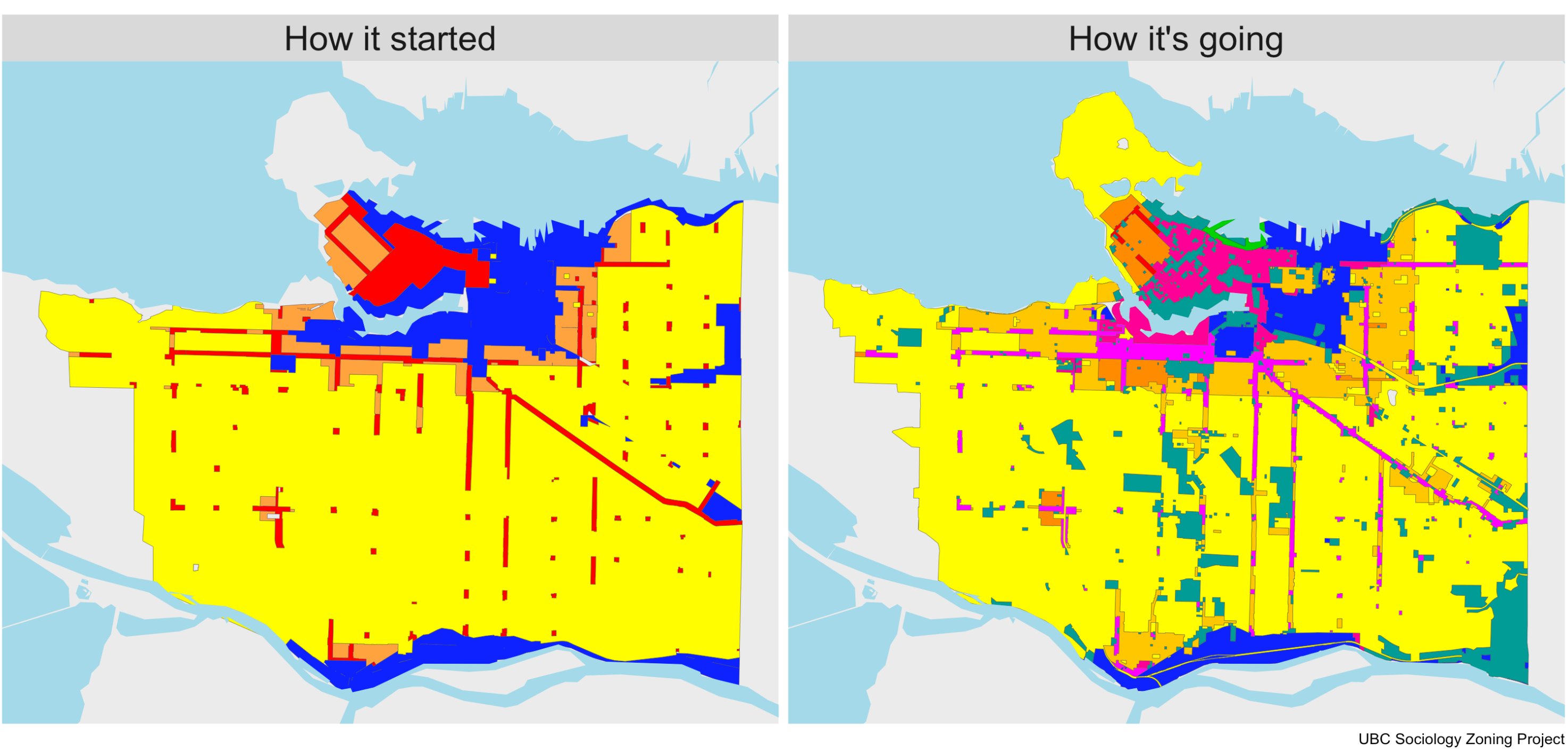 --- ### The Rooming Houses of Shaughnessy Secondary suites & laneway houses have helped maintain density of former single-family zones. But historically even low-profile attempts to densify the City have often been shut down, as with Shaughnessy's rooming houses, gradually enforced out by restrictions after WWII, returning Shaughnessy to an elite planned neighbourhood rather than allowing it to evolve into an up-and-coming home for multifamily apartment buildings. <table> <tr> <th>Shaughnessy Multifamily & Rooming Houses (darkened) in 1954 City Use Map</th> <th>Shaugnessy Multifamily & Rooming Houses (darkened) in 1984 City Use Map</th> <th>Current land use</th> </tr> <tr> <td style="width:300px;"><img src="https://homefreesociology.files.wordpress.com/2021/07/shaughnessy_1954_cov_use_map_d4741e0e-e7e5-43ec-b00d-3e7d5e4500b0-leg1269.1.jpg"/></td> <td style="width:300px;"><img src="https://homefreesociology.files.wordpress.com/2021/07/shaughnessy_1984_cov_use_map_12b3cfd7-2ba1-4b1e-a3ab-35120b83755a-pd1984.jpg"/></td> <td style="width:300px;"><img src="images/shaughnessy_now.png"/></td> </tr> </table> --- ## A regional look at zoning Zooming out we get a sense of broader zoning constraints across the Metro Vancouver region. [<img src="images/yvr_zoning_map.png" height="450px"/>](https://mountainmath.ca/zoning_map) --- ## Fine-grained change in population density <a href="https://doodles.mountainmath.ca/html/yvr_pop_timeline" target="_blank"><img src="https://doodles.mountainmath.ca/images/van_pop_change_3d.png"></a> --- ### Zoned density (by zoning category) Zoning categories can be summarized in bands reaching out from downtown Vancouver, and largely explain much of what we observe in terms of population density gradients. .pull-left.width-75[ <!-- --> ] .pull-right.width-20[ <img src="images/yvr_density_gradient_2015.png" width="200px" style="margin-top:60px"/> ] --- ### Zoned density (by FSR) Another way to think of it is that population density (both residential and job) follows building density. Here are residential FSRs, calculated in as lot averages in bands moving outward from downtown. .pull-left.width-75[ <!-- --> ] .pull-right.width-20[ <img src="images/yvr_density_gradient_2015.png" width="200px" style="margin-top:60px"/> ] --- ## Skytrain zoning .pull-left.width-65[ 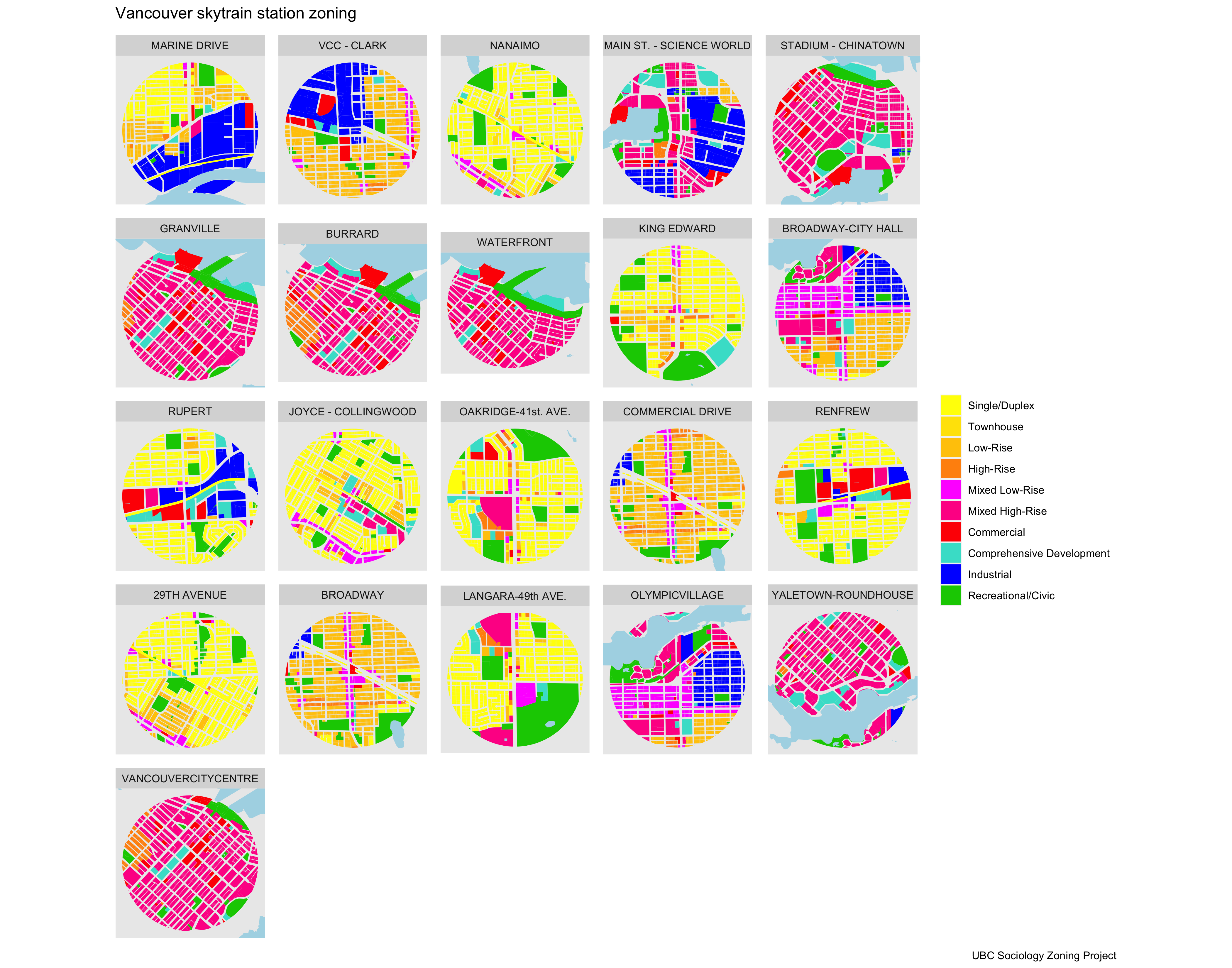 ] .pull-right.width-30[ Distance from the CBD is not quite the right metric though, we should use travel time instead. In that sense the surroundings of rapid transit stations are much "closer" to downtown. Zoning has not adapted even near rapid transit stations, some of which were opened decades ago. Some stations are surrounded by a sea of low-density zoning (yellow). ] --- ## Job opportunity Ultimately cities serve people best when they enable us to easily move between our daytime and nighttime worlds match-making between people, jobs, schools, and amenities. Resist fragmenting the labour market even more. <img src="https://mountainmath.ca/images/jobs_db.png" style="max-height:4.7in"> ??? We need to stop trying to fragment the region's labour market and work toward increasing opportunity and access to amenities and jobs across the region. --- ### Vancouver area commute patterns <iframe width="900px" height="530px" src="https://flowmap.blue/13Q-xsfL59XXPw7-3ue_9G9xab9FtYiL3S9vOZp-yJyY/embed?v=49.223692,-122.941214,9.39&a=1&b=1&c=1&d=1<=1&col=Default&f=45" frameborder="0" allowfullscreen></iframe> --- ### Location of growth determines commute mode  --- ## The future of Vancouver Currently the Metro Vancouver growth plan calls for: * decentralized growth anchored around designated Urban Centres * decentralized jobs growth to match the desired population pattern Alternative visions: * allow growth to better match "natural" density gradient * use land value, travel time,and similar metrics to guide this process * For any of these visions we will have to update zoning